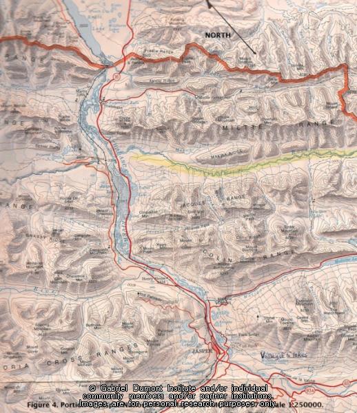
Figure 04. Upper Athabasca River Valley winter range locales inside and outside the Rocky ...
 |
|
| Title: | Figure 04. Upper Athabasca River Valley winter range locales inside and outside the Rocky ... |
| Creator: | Elliott, Jack |
| Subject: | Snare, Snake, Iroquois, Freeman, Athabasca, Jasper National Park, Archeology, Grande Cache |
| Description: | Figure 4. Upper Athabasca River Valley winter range locales inside and outside the Rocky Mountain eastern ranges. The two locales are divided by the park boundary depicted left-to-right across the upper portion of the image. Also shows the trail route between Southesk (Cairn) Pass and the upper Athabasca Valley. Portion of Jasper National Park Sheet MCR217. Canada Dept. of Energy, Mines and Resources, 1974. Scale of 1: 250000.
This essay is an ethnohistory and archeological survey of the Snare, Snake and Iroquois who lived in and used the resources of the Upper Athabasca region centering on Jasper National Park. The Iroquois settled the region as hunters, trappers, and fur trade voyageurs, eventually founding several unique Iroquois-Métis family in around Grande Cache. This document and its allied imagery are the copyright of the author, Jack Elliott who kindly granted permission to the Institute to put this work on this website. The information contained in the document and its allied imagery are the copyright of the author and can only be cited for reference purposes. |
| Date: | Prehistory-1900s |
| Type: | Image |
| Date of Copyright: | June 22, 2012 |
| Coverage: | Jasper National Park, Upper Athabasca Country, Alberta |
| GDI Media Filename: | Figure 4 [800x600].jpg |